2010 and 2011 Permit Waypoints
Black River Woody Debris Coordinates
Taken by Tucker, Cwalinski, Bruot July 30, 2009
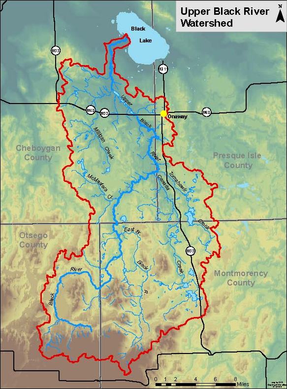
Upper Black River Watershed Restoration Committee
Area covered: Beaver Dam Club off Chandler Dam Rd downstream to about 1/8 mile below Trail 95 cul-de-sac; situated in the special regulations fishing reach
Goals:
- create diverse in-stream habitat
- increase surface area for periphyton and macroinvertebrates
- scour sand, accumulate silt, uncover cobble and rock
- create additional holding cover for yearling and older brook trout
- create additional cover for young of year (age 0) brook trout and increase survival to age 1 in an area where reproduction is highest for this river
- add debris to previously placed structures which are not dense enough to accomplish goals
LWD = large woody debris, larger diameter trees anchored together with various wood accumulation
SWD = small woody debris, smaller diameter trees and brush
R= right bank facing downstream
L= Left bank facing downstream
Bundles = LWD or SWD
Waypoint 001 - done
-Beaver Dam Club property
Waypoint 002 - done
-add to natural fallen trees on R bank just down from waypoint
Waypoint 003 - done
-add 3-4 LWD structures, alternating fashion, beginning with the first one at head of riffle on L bank, second downstream on R bank
-fill in behind large logs most downstream
Waypoint 004 - done
-add 1 long LWD structure on L bank around silt bed, then add 1 more LWD structure downstream ~ 40= downstream on same side (at the field parking area)
Waypoint 005 - done
-alternate 4 structures of LWD and SWD over 150= reach
Waypoint 006 - done
-straight flat reach with an old dock underwater in river
-alternate 6 bigger LWD structures downstream
-pictures 1-3
-2 standing dead cedars on R bank
Waypoint 007 - done
-old beaver dam
-add 2 structures (opposite sides) of LWD
Waypoint 008 - done
-long straight reach currently lightly impounded
-add 5-6 LWD and SWD structures in alternating fashion
Waypoint 009 - done
-fresh beaver dam
Waypoint 010 - done
-add 3-4 structures of LWD in alternating fashion
Waypoint 011
-add LWD to natural structures on both banks, adding about 4-5 structures
-dead birch on R
-dead balsam in river angled which should be used as last downstream structure
Waypoint 012
-add 3-4 alternating structures including SWD and LWD for younger fish
Waypoint 013
-riffle-tag alder reach which should have 7-8 alternating structures throughout
Waypoint 014
-feeder tributary on R bank, wide spot
-fill both sides upstream of mid-stream boulder, 2-3 LWD and SWD structures
Waypoint 015
-road parallels river
-add 3-4 structures starting at silt bed on L bank about 100= upstream from road/bend
Waypoint 016 – partially complete
-shallow reach downstream of where the road and river parallel one another
-add 5-6 structures extending downstream for ~ 200= in alternating fashion
Waypoint 017 – partially complete
-add to right bank structure and put large root wad on R bank in river if possible, put another structure downstream on L before private property white sign
Waypoint 018
-upstream of riffles approximately 100-200= (private?), add 2 alternating LWD structures
Waypoint 019
-R big cedars alternate or build onto with about 4-5 structures downstream of where the riffle begins
Waypoint 020
- alternate or build onto with about 4-5 structures downstream
Waypoint 021
-add behind current natural structure; add 1 small structure on L grassy bank, downstream, then add 4 alternating structures downstream in straight reach ~300=
Waypoint 022
-root wad on L side of channel; add structure behind, below, and above, anchor root wad too
-alternate 3-4 structures downstream to pipeline
Waypoint 023
-L side island, fill woody debris at the head of it to concentrate flow, then alternate 2 structures on right with 1 structure on left down to the hanging birch tree ~100=
Waypoint 024
-add 1 structure on R bank, constricted to bank
-lots of dead timber
-downstream ~ 50= if beaver/log jam narrowing; cut L end side of jam ~ 6-8= and fill in behind the dam structure on R bank with additional materials
Waypoint 025
-add to natural fallen materials on R bank, then add 2-3 structures on L bank downstream for 100-150=
-use silt bank for a structure on L side downstream behind 2 large spruce trees
Waypoint 026
-add 2-3 structures in alternating fashion but mainly R bank, include natural structures along bank on R, and use plenty of wood
-can see Waypoint 27 from this location
Waypoint 027
- camp site in bend of Chandler Dam Rd
-pool and bend in river
Waypoint 028 – partially complete
-For 600= downstream, alternate various sized structures (many), adding to the existing natural structures, include 1-2 in middle (smaller) that do not restrict flow or navigation
-the downstream end of this reach should be the High Country Pathway bridge and include the 2 small beaver structures directly below it
Waypoint 029
-add structure on L to few natural trees, fill in hole
-add structure on R to established beaver wood pile
Waypoint 030
-grassy island
-add a small structure around the island but do not block off smaller L channel
-add 1-2 structures downstream to beaver dam remnants
Waypoint 031
-riffle/run reach for ~ 250=
-alternate many structures downstream through flat reach, including ample SWD, about 6-7 structures total
Waypoint 032
-head of riffle
-add 2 structures opposite of each other at head, then some SWD structures on R bank
Waypoint 033
-add 2 structures opposite of each other at head, then some SWD structures on R bank
Waypoint 034
-add lunker structure (long and narrow) extending from L bend/bank for length of it, which is ~ 60-70= long; then add 1-2 structures alternating downstream to and around small grassy island on R bank
Waypoint 035
-shallow left channel
-add large structure on L bank to narrow it down for young fish cover
Waypoint 036
- channels come together; add long structure on R bank and another structure on L bank by grass area, then add 2 more structures downstream on R bank
Waypoint 037
-long narrow Lunker structure length of L grassy bank; structure ~ 80= long
-then alternate 2 structures downstream, R, then L by spruce trees
Waypoint 038
-alternate 4 structures including 2 across from each other at riffle head, put throughout riffle area and include SWD
Waypoint 039
-private cabin on L hill
-add to artificially anchored log in front of cabin, but only small amount, some behind structure
Waypoint 040
-downstream starting at 50= below log sill, add good amount of SWD to natural wood on R bank; then add small lunker structure along left grassy bank using arced natural log for ~ 30=
Waypoint 041
-bend on R, fill with LWD for the entire bend length ~ 80-90=; at tail end is L side silt bed pocket, add 1 structure at this spot as well; then for 70= downstream alternate 2 structures
Waypoint 042
-starting at mid-river boulders
-put 2 structures opposite of each other, then alternate 2 structures on L, then R bank before grassy bank
Waypoint 043
-grass bend on left
-wood structure starting at tag alder clump and extending to and just beyond natural debris pile to ending pile clump; then add 1 structure at bend ~ 50= downstream on R
Waypoint 044
-start on R bank and alternate ~ 8 structures as far as you can see downstream
Waypoint 045
-start on L bank and alternate ~ 8 structures as far as you can see downstream
Waypoint 046
-trail/small walk site comes down to river in flat shallow reach on R bank
-alternate structures but add to natural debris on R bank, while adding at least 3 structures to L bank for ~ 300= downstream or to grassy island with debris around it
Waypoint 047
-Trail 94 cul-de-sac and trail (in grass meadow) on L by islands
-add structures on L bank in silt beds for ~ 50=
Waypoint 048
-flat wide reach
-add 6-7 alternating structures downstream as far as can be seen